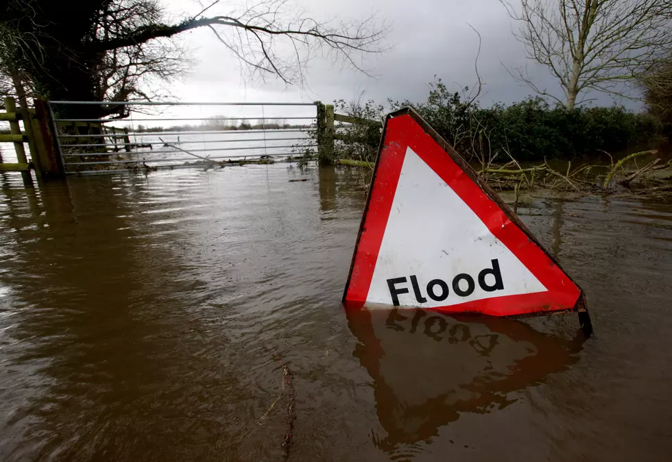
Flash Flood Watch Issued For CNY Today – June 20
A tricky situation exists for flash flooding with the heavy rainfall and damaging winds.
NWS says a low-pressure system will bring more showers and thunderstorms to CNY today through tonight, with localized flash flooding possible. Some storms may contain gusty winds. High pressure will take over for Friday into the weekend, with dry weather, before the next system moves into the area on Monday.
* Flash Flood Watch for a portion of central New York, including
the following areas, Chemung, Cortland, Madison, Northern
Oneida, Onondaga, Schuyler, Seneca, Southern Cayuga, Southern
Oneida, Steuben, Tioga, Tompkins, and Yates.
* Scattered showers and thunderstorms will move through central
New York this morning into the afternoon. Some storms will
contain heavy rain, capable of producing localized flash
flooding. Areas with recent rainfall will be particularly
vulnerable.
PRECAUTIONARY/PREPAREDNESS ACTIONS...
A Flash Flood Watch means that conditions may develop that lead to flash flooding. Flash flooding is a very dangerous situation.
You should monitor later forecasts and be prepared to take action
should Flash Flood Warnings be issued.
* Flood Advisory for Minor Flooding in Poor Drainage Areas for...
Oneida County in central New York...
* At 811 AM EDT, Doppler radar indicated locally heavy rain that will cause minor flooding of streets and other poor drainage areas in the advisory area. Some locations in Onondaga and Madison
counties have received over an inch of rainfall in less than 1
hour.
* Some places that will experience flooding include...
Utica, Rome, Oneida, Kirkland, Lee, Verona, Westmoreland, Vienna,
Trenton and Paris.
PRECAUTIONARY/PREPAREDNESS ACTIONS...
Excessive runoff from heavy rainfall will cause minor flooding of small creeks and streams, urban areas, highways, streets, and underpasses as well as other drainage areas and low lying spots.
NWS says a tricky situation exists for today in terms of flash flood potential. It is still difficult to narrow down just where flash flooding will occur, but high potential along with some very sensitive locations due to recent heavy rain, also makes it challenging to rule out just about anywhere in our area. A Flash Flood Watch has thus been hoisted areawide; today for northwestern zones and this afternoon through evening central to southeastern zones.
Extended Forcast:
Today: Showers and possibly a thunderstorm before 2pm, then showers and thunderstorms between 2pm and 4pm, then showers and possibly a thunderstorm after 4pm. Some of the storms could produce heavy rain. High near 71. Southeast wind around 7 mph becoming north in the afternoon. Chance of precipitation is 100%. New rainfall amounts between three quarters and one inch possible.
Tonight: Showers likely and possibly a thunderstorm. Cloudy, with a low around 59. Northwest wind 6 to 8 mph. Chance of precipitation is 70%. New precipitation amounts between a quarter and half of an inch possible.
Friday: A chance of showers, mainly before 8am. Partly sunny, with a high near 72. Northwest wind 9 to 14 mph. Chance of precipitation is 30%. New precipitation amounts of less than a tenth of an inch possible.
Friday Night: Partly cloudy, with a low around 52. West wind 5 to 10 mph.
Saturday: Sunny, with a high near 72. Northwest wind 8 to 14 mph.
Saturday Night: Mostly clear, with a low around 52.
Sunday: Sunny, with a high near 78.
Get up to information on power outages throughout Central New York; where it’s out and when it’ll be restored with National Grid’s Power Outage Map.
National Grid also offers text alerts on the latest efforts to restore power.
To receive free text message alerts and updates, text the word STORM to NGRID (64743). E-mail alerts are available to customers who create an online profile on the company’s website. All alert services can be started and stopped at the customer’s request.
You can even report power outages or get the latest information at the National Grid’s website.
Power Outage Preparation:
*Keep your cell phone charged and make sure you know where your backup power supply is.
*Make sure all your flashlights have fresh batteries.
*Fill your gas tank. You can use your car to keep warm and recharge devices.
*Have some food available that you don’t need to cook.
* Download The Eagle App. You’ll receive local alerts, weather reports and more with push notification.
More From WIBX 950